Showing 176 items matching victoria rocks
-
 Glenelg Shire Council Cultural Collection
Postcard - Postcard - Bailey's Rocks, Casterton, Victoria, n.d
... Postcard - Bailey's Rocks, Casterton, Victoria..., Casterton, Victoria Postcard Photo/postcard of Bailey's Rocks, near ...Photo/postcard of Bailey's Rocks, near Casterton. Reverse has mailing details, brief description Bailey's Rocks. -
 The Beechworth Burke Museum
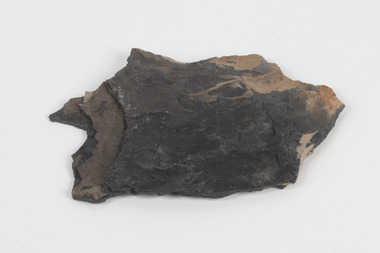
Geological specimen - Slice Dendrites on Sandstone, Unknown
... Victoria rocks... of Victoria Grampians Victoria rocks minerals rocks manganese oxides ...Dendrites are deposits of black minerals, typically manganese oxides that precipitated from water seeping through fractures in fine-grain rocks like a sandstone or limestone. Dendrites are much less regular than plant fossils and lacks vein structures. The manganese cryztallizes through the process called 'supercooling'. Some samples of dendrites occur in volcanic rocks in the Lilydale district, east of Melbourne. Sandstones are made of tiny sand grains that may have been deposited in the sea and later formed together. Most sandstones are made of quartz which are chemically-resistant minerals. This particular specimen was donated by Alfred Selwyn in 1868 as part of the Geological Survey of Victoria. It is connected to the original 1875 catalogue on Geological Specimen with number 189 'Quartz Crystals_Quartz Crystals (two are polished)'Dendrites on sandstones This specimen is an important contribution to the geological history of Victoria, as well as its links to the 1868 Geological Survey of Victoria. This specimen is part of larger collection of significant geological specimens in the Burke Museum that was collected from around the world between 1868-1880. A large percentage of these specimens were collection as part of the Geological Survey of Victoria 1852-1974. The Geological Survey of Victoria was an organisation founded in response to the Victorian gold rush to explore the geological and mineral resources and to record a detailed map of the state. It was headed by British geologist, Alfred Richard Cecil Selwyn (1824-1902), who was responsible for issuing over 60 geological maps during his 17 years as director. These maps were all hand-drawn and coloured and became the benchmark for accuracy for geological mapping. Collecting geological specimens was an important part of mapping and understanding the scientific makeup of the earth. Many of these specimens were sent to research and collecting organisations across Australia, including the Burke Museum, to educate and encourage further study. A hand-sized slice of light brown sandstone with dendrites formed from crystallized manganese oxide.Existing label: Not sure what / 'Slica dondrites' / means. / Sample is sandstone and original label / identifies it as from / the Grampians near Stawell. / C. Willman / 15/4/21 Other label: [illegible] / stone [ illegible] / from Grampians Stawell / 1894 /geological specimen, geology, geology collection, burke museum, beechworth, dendrites, sandstones, quartz, lilydale district, geological survey of victoria, grampians, victoria rocks, minerals, rocks, manganese oxides, alfred selwyn -
 The Beechworth Burke Museum
Geological specimen - Oil shale
... Selwyn Wolgen Valley 1868 Geological Survey of Victoria rocks ...This particular specimen is found in Wolgan Valley, New South Wales. It could be linked to the abandoned oil shale mining sites in Wolgan Valley such as Newnes. Newnes was an industrial complex operational in the early 20th century is now partly surrounded by Wollemi National Park. It produced motor spirit, kerosene, and gas oil. Newnes's Torbanite oil shale rock contained around 350 litres of oil shale per tonne. The Torbanite was mined by the Commonwealth Oil Corporation Ltd. Oil shale is a sedimentary rock and also a form of fossil fuel. It is often formed millions of years ago and usually contain fossilised remains of plants and/or animals. Oil shale is rich in kerogen that releases hydrocarbon when heated. These hydrocarbon can be used as an alternative petroleum or natural gas. The oil-shale rock was converted into oil by "destructive distillation"; the rock being heated until it broke down to form an oily vapour and an ash residue. Oil bearing shale is one of Australia's national assets. There are many oil companies established in Australia. It reflects Australia's rich natural resources as well as connection to the Australia's engineering and oil industry. The booming oil shale extraction businesses can be traced as far back as 1920s. This specimen is part of a larger collection of geological and mineral specimens collected from around Australia (and some parts of the world) and donated to the Burke Museum between 1868-1880. A large percentage of these specimens were collected in Victoria as part of the Geological Survey of Victoria that begun in 1852 (in response to the Gold Rush) to study and map the geology of Victoria. Collecting geological specimens was an important part of mapping and understanding the scientific makeup of the earth. Many of these specimens were sent to research and collecting organisations across Australia, including the Burke Museum, to educate and encourage further study.Piece of dark gray oil bearing shale with shades of light brown and fossilised leavesExisting label: OIL BEARING SHALE with / FOSSILISED LEAVES / Locality: Wongan Valley, NSW / Donor: Miss M. Cambell geological specimen, geology, geology collection, burke museum, beechworth, oil shale, shale, fossil fuels, alfred selwyn, wolgen valley, 1868 geological survey of victoria, rocks, sedimentary rocks, newnes, torbanite, commonwealth oil corporation ltd -
 The Beechworth Burke Museum
Geological specimen - Fossil Leaves
... Geological Survey of Victoria lithified rocks fossilised leaf rock ...A fossil refers to any remains or traces of past life that are preserved in the rock. It could be remains of plants or animals. Fossil leaves are commonly found on different types of rocks. These fossils can go as far back as the Triassic Age just like the series of fossil plants collected at Denmark Hill, Ipswich in Queensland. Fossils leaves are formed when dead plants get buried by sediments like mud, sand, or volcanic ash. Often, it gets detached cleanly from stems along a special layer of weak cells, then twigs, and, less commonly, cones of conifers and fruits and seeds of flowering plants. Over time, the leaves or pieces of leaves get buried by more sediments and eventually gets 'lithified' or hardened into a rock. Erosions and mining can cause the rocks to break and reveal the fossils buried in it. Fossilisation frequently takes place at sites in the lowlands where deposits of clay, silt, sand are found. This is usually due to weathering and erosion of rocks. Fossil leaves can provide information about ancient Australia's way of living. It contributes to Victorian biodiversity records and its botanical collections. It also contributes information on the geographical profile of Victoria as fossilisation usually occur at estuaries and deltas of rivers, river flood plains, ponds and lakes. This specimen is part of a larger collection of geological and mineral specimens collected from around Australia (and some parts of the world) and donated to the Burke Museum between 1868-1880. A large percentage of these specimens were collected in Victoria as part of the Geological Survey of Victoria that begun in 1852 (in response to the Gold Rush) to study and map the geology of Victoria. Collecting geological specimens was an important part of mapping and understanding the scientific makeup of the earth. Many of these specimens were sent to research and collecting organisations across Australia, including the Burke Museum, to educate and encourage further study.Piece of light brown rock with fossilised leaves in shades of golden yellow and brown.Existing label: Fossil Leaves / Locality unknown / might be worth checking if this is Glossopteris, a Permian age plant. / C. William 16/4/21 geological specimen, geology, geology collection, burke museum, beechworth, fossil leaves, fossilization, 1868 geological survey of victoria, lithified, rocks, fossilised leaf, rock, fossils, leaves -
Whitehorse Historical Society Inc.
Document, Intrusive rocks of Melbourne, 1976
... Copy of page 373 from 'Geology of Victoria' on intrusive... Copy of page 373 from 'Geology of Victoria' on intrusive rocks ...Copy of page 373 from 'Geology of Victoria' on intrusive rocks of Melbourne by K.G. Bowen.Copy of page 373 from 'Geology of Victoria' on intrusive rocks of Melbourne by K.G. Bowen. At Tally Ho there is a circular plug, considered to be quartz diorite.Copy of page 373 from 'Geology of Victoria' on intrusive rocks of Melbourne by K.G. Bowen.mines and mining, geological society of australia -
 The Beechworth Burke Museum
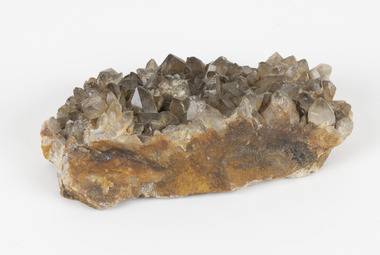
Geological specimen - Smoky quartz crystals, unknown
Quartz is an extremely common mineral to find across the world. Quartz can have two forms; Microcrystalline quartz or Crystalline quartz. Microcrystalline quartz is a fine grain quartz where crystalline quartz is often a large crystal. This specimen is a crystalline quartz. Made of silicon oxide, this specimen is called smokey quartz crystals because of its brownish colour. However, the colour of quartz can vary. In addition, quartz are formed in deep-seated igneous rocks and crystallized through hot aqueous solutions. This type of crystal can be found all over Australia, including Beechworth in Victoria. Other places quartz can be found is the Ashburton River area in Western Australia, Marlborough in Queensland, the Lune River area in Tasmania and Kingsgate in New South Wales. This specimen is significant because it is common to find this kind of mineral. While the location of where this specimen was originally from is unknown, it highlights the many places in Australia where quartz is found. It demonstrates that quartz makes up a large portion of Australia's geology. In addition, quartz itself can vary in its colour and shape. This specimen represents one of these variations. That being smoky quartz crystals. This specimen is part of a larger collection of geological and mineral specimens collected from around Australia (and some parts of the world) and donated to the Burke Museum between 1868-1880. A large percentage of these specimens were collected in Victoria as part of the Geological Survey of Victoria that begun in 1852 (in response to the Gold Rush) to study and map the geology of Victoria. Collecting geological specimens was an important part of mapping and understanding the scientific makeup of the earth. Many of these specimens were sent to research and collecting organisations across Australia, including the Burke Museum, to educate and encourage further study.A large hand-sized quartz mineral with shades of brown and gray throughout.Smoky quartz / crystals /locality/ unknown / (needs a wash) /BBgeological specimen, geology, geology collection, burke museum, beechworth, microcrystalline, quartz, quartz mining, quartz reefs beechworth, smokey quartz crystals, crystals, crystalline, silicon oxide, brown, colour, igneous rocks, magma, ashburton river, western australia, marlborough, queensland, lune river, tasmania, kingsgate, new south wales, nsw -
 The Beechworth Burke Museum
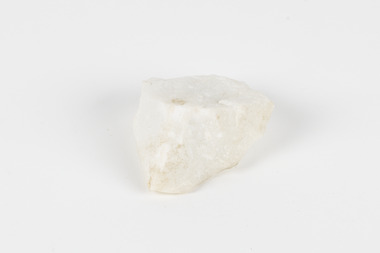
Geological specimen - Kaolin, unknown
Kaolin is also known as china clay. This specimen came from Dunolly, Victoria and was donated to the Museum in 1868 as part of the Geological Survey of Victoria. This survey helped map and study the geology of Victoria. In Victoria, Kaolin is particularly used as a filler and coating material in paper manufacture. It can also be used in paints, ceramics, rubbers and plastics. There are many kaolin deposits in Victoria but many of these have been mined out and there is not much Kaolin left. Rocks that have a high amount of Kaolinite and it can be formed through the decomposition of other materials. There are two types of Kaolin; hard and soft kaolin. Soft kaolin's are coarse but have a soapy texture. It can also break easily. The hard kaolins have an earthly texture and are finer grained. This means that they are harder to break, unlike the soft kaolin. Hard kaolin's are formed by flocculation in salt water, a process that in basic terms, bonds particles together. Kaolin is a common material in Victoria and that is why it is significant. While this specimen was mined in Dunolly, Victoria Kaolin can also be found Pittong, Pakenham, Bulla, Hallam and Ballarat as well as many other places throughout Victoria. This specimen represents the presence of Kaolin deposits in this region of Australia. It is also significant because Kaolin has many uses and is largely beneficial to many manufacturing processes in Victoria. This specimen is part of a larger collection of geological and mineral specimens collected from around Australia (and some parts of the world) and donated to the Burke Museum between 1868-1880. A large percentage of these specimens were collected in Victoria as part of the Geological Survey of Victoria that begun in 1852 (in response to the Gold Rush) to study and map the geology of Victoria. Collecting geological specimens was an important part of mapping and understanding the scientific makeup of the earth. Many of these specimens were sent to research and collecting organisations across Australia, including the Burke Museum, to educate and encourage further study.Two pieces of Kaolinite mineral with shades of white and graygeological specimen, geology, geology collection, burke museum, beechworth, kaolin, china clay, dunolly, geological survey of victoria, kaolinite, victoria, mining, mining deposits, geology of victoria, australia, filler, coating material, paper manufacture, paint, ceramics, rubbers, plastics, decomposition, materials, soft kaolin, hard kaolin, flocculation, particles, salt water -
 The Beechworth Burke Museum
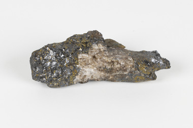
Geological specimen - Actionlite and Pyrite
Actinolite is usually found in metamorphic rocks, such as contact aureoles surrounding cooled intrusive igneous rocks. It also occurs as a product of the metamorphism of magnesium-rich limestones. Pyrite is usually found with other sulfides or oxides in quartz veins, sedimentary rock, and metamorphic rock, as well coal beds, and as a replacement mineral in fossils. Actinolite is an amphibole silicate mineral. It is named after the Greek word "aktinos" meaning “ray” in allusion to the mineral's fibrous nature. Fibrous actinolite is a type of asbestos and was once mined along Jones Creek at Gundagai, New South Wales. Pyrite or "Fool's Gold" is the most common sulfide mineral. It is named after the Greek "pyr" meaning "fire" because it can be used to create sparks needed for a fire if struck against metal or a hard surface. Due to its gold colour, pyrite can be mistaken for gold and often forms alongside it, causing small amounts of gold to be present in rocks containing pyrite. Most importantly, pyrite is an ore of gold. Pyrite is sometimes used as a gemstone but is not great for jewellery as it easily tarnishes. In some fossils of ammonites – shelled cephalopods that died ~66 million years ago – pyrite also replaces the shell. This specimen is part of a larger collection of geological and mineral specimens collected from around Australia (and some parts of the world) and donated to the Burke Museum between 1868-1880. A large percentage of these specimens were collected in Victoria as part of the Geological Survey of Victoria that begun in 1852 (in response to the Gold Rush) to study and map the geology of Victoria. Collecting geological specimens was an important part of mapping and understanding the scientific makeup of the earth. Many of these specimens were sent to research and collecting organisations across Australia, including the Burke Museum, to educate and encourage further study. A small-medium-sized solid specimen with the minerals actinolite (dark green fibrous) and pyrite (brassy) with shades of brown, black/grey, and white. Actinolite is an amphibole mineral in the tremolite-actinolite series of calcium, magnesium, and iron silicates. Pyrite is an iron disulfide mineral.geological specimen, geology, geology collection, burke museum, beechworth, indigo shire, geological, mineralogy, pyrite, actinolite, victoria, sewyln, alfred selwyn -
 The Beechworth Burke Museum
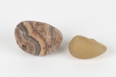
Geological specimen - Agate and Quartz pebbles
Agate occurs when amygdales (gas pockets) form in the upper levels of basaltic lava flows. If these pockets or bubbles are iniltrated by water bearing silica in solution, the fluid dries and hardens in layers, forming round or egg shaped nodules or geodes within the rocky matrix. Agate is formed of a silica mineral chalcedony similar to quartz. Although relatively common and semi-precious, agate has been prized since at least 1450 BC - an intricately carved agate seal was found in the 2015 excavation of a grave belonging to a Mycenaeum priest or warrior near Pylos in Greece. Agate is also used in jewellery and other decorative or ritual purposes due to its often striking appearance. Quartz is found all over Australia, including Beechworth in Victoria. It is formed in deep-seated igneous rocks and crystallized through hot aqueous solutions. It can have two forms; Microcrystalline quartz or Crystalline quartz. Microcrystalline quartz is a fine grain quartz where crystalline quartz is often a large crystal. The colour of quartz can vary. These specimens were collected in Victoria in the vicinity of the Burke Museum. Victoria and other regions of Australia were surveyed for sites of potential mineral wealth throughout the 19th Century. The identification of sites containing valuable commodities such as gold, iron ore and gemstones in a locality had the potential to shape the development and history of communities and industries in the area. The discovery of gold in Victoria, for instance, had a significant influence on the development of the area now known as 'the goldfields', including Beechworth; the city of Melbourne and Victoria as a whole.The specimens are significant as examples of surveying activity undertaken to assess and direct the development of the mineral resource industries in Victoria and Australia, as well as the movement to expand human knowledge of earth sciences such as mineralogy and geology in the nineteenth century.Geological specimens of Agate and Quartz respectively; the fist-sized piece of Agate has peach/coral colouring with grey concentric patterning and the smaller piece of quartz is a uniform yellow/orange shade. Existing label: Local pebbles / (agate and / quartz / (yellowish) / egg-shaped). / BB geological specimen, geology, geology collection, burke museum, beechworth, agate, quartz, north-east victoria, indigo shire, geological surveys -
 The Beechworth Burke Museum
Geological specimen - Sphalerite, Unknown
Sphalerite or sphaelerite is named from the Greek word for 'treacherous' or 'deceiver' as specimens can vary widely in appearance, making them hard to visually identify. It is a zinc sulfide with the chemical composition (Zn,Fe)S, the most important ore of zinc. Specimens of sphalerite can contain iron as a substitute for up to 25% of the usual zinc present, as well as trace elements of gallium, cadmium, geranium and indium. Small amounts of arsenic and manganese may also be detected. Sphalerite is found in igneous, sedimentary and metamorphic rocks. It forms when carbonate rock encounters acidic, zinc-bearing fluid. It often forms in veins or in fissures of the existing rock, with colours and crystal shapes dependent on the composition of the the combining elements. It forms isometric crystal shapes including cubes, tetrahedrons, octahedrons, dodecahedrons. This specimen was collected in approximately 1852, in Broken Hill, NSW, as an adjunct to the Geological Survey of Victoria. It was donated to the Museum in 1868. Victoria and other regions of Australia were surveyed for sites of potential mineral wealth throughout the 19th Century. The identification of sites containing valuable commodities such as gold, iron ore and gemstones in a locality had the potential to shape the development and history of communities and industries in the area. The discovery of gold in Victoria, for instance, had a significant influence on the development of the area now known as 'the goldfields', including Beechworth; the city of Melbourne and Victoria as a whole.The specimen is significant as an examples of surveying activity undertaken to assess and direct the development of the mineral resource industries in Victoria and Australia, as well as the movement to expand human knowledge of earth sciences such as mineralogy and geology in the nineteenth century.A pipe-shaped specimen of sulfide-mineral zinc ore displaying patches of black, brown, beige and gold colouring. The main item has associated broken pieces. geological specimen, geology, geology collection, burke museum, beechworth, mineralogy, indigo shire, geological survey, sphalerite, sphaelerite, zinc ore, broken hill, nsw, victoria, galena, fluorite, chalcopyrite, lead, cadmium, gallium, germanium, indium, iron -
 The Beechworth Burke Museum
Geological specimen - Marble, Unknown
A granular metamorphic rock, marble is derived from limestone or dolomite and composed of calcite or dolomite interlocking grains. Heat and pressure from overlying sediments form it from limestone buried deep in Earth's crust. Graphite, pyrite, quartz, mica, and iron oxides can affect rock texture and colour. This specimen was found in Carrara, Italy. Carrara marble is the most common marble found in Italy, and it gets its name from the region where it is located. The marble was also called Luna marble and was used as a decorative element in buildings and sculptures. It has been quarried since Roman times in the Lunigiana, the northernmost tip of Tuscany, just outside the city of Carrara in the province of Massa and Carrara.Marble is one of the most popular and expensive rocks used in sculpture, architecture, interior decorations, statues, table tops, and novelties. It is available in various colors and textures depending on the chemical composition. The strength of the rock and its ability to hold finer details have made it a favorite among designers. This specimen is part of a larger collection of geological and mineral specimens collected from around Australia (and some parts of the world) and donated to the Burke Museum between 1868-1880. A large percentage of these specimens were collected in Victoria as part of the Geological Survey of Victoria that begun in 1852 (in response to the Gold Rush) to study and map the geology of Victoria. Collecting geological specimens was an important part of mapping and understanding the scientific makeup of the earth. Many of these specimens were sent to research and collecting organisations across Australia, including the Burke Museum, to educate and encourage further study.A solid hand sized Marble (metamorphic rock) predominantly white with specks light grey and ochre geological specimen, geology, geology collection, burke museum, beechworth, marble, carrara marble, italian marble, marble specimen, tuscany -
 The Beechworth Burke Museum
Geological specimen - Olivine Crystals, Unknown
Olivine is mostly found on the Earth's surface in igneous rocks that are dark-coloured. It is common at divergent plate boundaries and at warm spots, such as volcanic areas. It crystalises and forms during the cooling of magma. Olivine is used in refractory sand, bricks, and gemstones. Olivine has been found on a number of meteorites, which might have originated from large asteroids or the mantle of a now-destroyed planet. This olivine crystal is thought to originate from Mount Noorat, with speculation that it could have originated from Mount Shadwell. Mount Noorat is a dormant volcano cone located in the Newer Volcanics Province of Victoria. Mount Noorat belongs to the Kirrae Wuurong people, who used the Mount as a place for meetings and gatherings prior to European settlement. Contact was first made between European settlers and the Indigenous people in 1841. The Mount has mostly been used for cattle and sheep grazing. Mount Shadwell is a well-known source of olivine and is the highest of a gathering of volcanic cones. The New Volcanic Province is located in South East Australia and covers 15000 square kilometres. It contains 400 explosive vents and small shield volcanoes. The last eruption is thought to have occurred 5000 years ago at Mount Gambier and Mount Schank. This olivine crystal has been identified as a volcanic bomb, which is a molten rock which was pushed out and ejected into the air when a volcano reupts. A rock needs to be larger than 65 mm in diameter to be classified as a volcanic bomb. This olivine volcanic bomb and its locality is historically and socially significant. The olivine was found in the Newer Volcanic Province, an area which contains over 400 dormant volcanoes. This olivine is one part of a volcanic bomb, which would have ejected when magma erupted out of a volcano. This specimen is part of a larger collection of geological and mineral specimens collected from around Australia (and some parts of the world) and donated to the Burke Museum between 1868-1880. A large percentage of these specimens were collected in Victoria as part of the Geological Survey of Victoria that begun in 1852 (in response to the Gold Rush) to study and map the geology of Victoria. Collecting geological specimens was an important part of mapping and understanding the scientific makeup of the earth. Many of these specimens were sent to research and collecting organisations across Australia, including the Burke Museum, to educate and encourage further study.A solid iron-magnesium silicate mineral with shades of green and brownburke museum, beechworth, geological, geological specimen, olivine, igneous rock, volcanic, gemstones, volcanic bomb, meteorites, asteroids, plantes, mount noorat, mount shadwell, indigenous, kirrae wuurong people, newer volcanics province, victoria, european settlement, eruption -
 The Beechworth Burke Museum
Photograph, Unknown
The A1 Gold Mine is located north of Woods Point, near Jamieson, in the Upper Goulburn region of Victoria. Gold was discovered at the A1 site in 1861 and mining operations began in 1864. The A1 Mine Settlement refers to a small township known variously as Castle Reef, Castle Point, and Raspberry Creek, which developed in the 1860s around mining industry centred on a crushing machine that worked the three gold reefs in the area. Historically, the name "A1"referred to the high quality of gold found in the quartz reefs at depths of at least two thousand feet. Along with the Morning Star mine at Woods Point, the A1 gold mine produced almost sixty percent of Victoria's gold output in the 1950s to 1970s and continued operating until 1992 when it went into administration. Operations at the site were revived in 2016 and the A1 Mine is now considered one of Victoria's premier gold mines. The A1 mine is part of the extensive and prospective Lachlan Fold Belt, a north-west trending belt of tightly folded Early Devonian sedimentary rocks extending from New South Wales to Victoria. Mineralisation is hosted within or immediately adjacent to diorite dykes. Contemporary development of the 'Queens Lode' at the A1 mine signals a move from high-grade, narrow vein airleg mining into larger scale, mechanical mining designed to increase ore production volume. This original, undated photograph of the A1 Mine appears to depict an area or phase of disuse or abandonment. The aged and humble appearance of the cottage suggests association with the historical A1 Mine Settlement, therefore the image may have been taken prior to the 1950s-1970s revival period in which the A1 mine is known to have produced high gold yields. The photograph contributes to our understanding of the A1 Gold Mine's impact on the landscape and the social, environmental impacts of mining on communities and may be compared with others in the Burke Museum's extensive collection of mining photographs to deepen our understanding of mining in the Jamieson area.Black and white rectangular photograph printed on photographic paperReverse: 5577 / A1 Mine / Near Jamieson / Vic. /burke museum, beechworth museum, beechworth, gold fields, gold rush, victorian gold rush, mining tunnels, gold ming history, colonial australia, australian gold rushes, mining technology, beechworth historic district, indigo gold trail, indigo shire, upper goulburn shire, jamieson, woods point-walhalla goldfield, a1 gold mine, victorian high country, modern mining methods, orogenic gold province, gold mineralisation, devonian, dykes -
 Phillip Island and District Historical Society Inc.
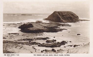
Photograph, The Nobbies, Phillip Island, c 1926
... View of The Nobbies and Seal Rocks, Phillip Island...The Rose Series P.665 The Nobbies and Seal Rocks... and Seal Rocks, Phillip Island, Victoria local history postcards ...View of The Nobbies and Seal Rocks, Phillip Island, Victoria. The Rose Series P 665The Rose Series P.665 The Nobbies and Seal Rocks, Phillip Island, Victorialocal history, postcards, the nobbies, seal rocks, phillip island, sepia photograph, ian reiher -
 Phillip Island and District Historical Society Inc.
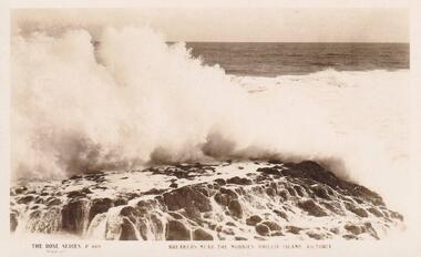
Photograph, The Nobbies, Phillip Island, c 1926
Sepia Postcard of breakers near The Nobbies The Rose Series P 669The Rose Series P 669. Breakers near The Nobbies, Phillip Island, Victorialocal history, postcards, the nobbies, phillip island, sepia photograph, ian reiher, seal rocks -
 Phillip Island and District Historical Society Inc.
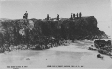
Photograph, Near Forrest Caves, Phillip Island
Part of a collection of 'Rose & Valentine' series of Post Cards. Copied by John Jansson 1984Black & White Postcard. View of rocks near Forrest Caves. Group of people on edge of the rock formation watching the waves.The Rose Series P3435. Near Forest Caves, Cowes, Phillip Island, Victorialocal history, photography, photographs, postcards, phillip island, black & white postcard copy, rock formation, forrest caves, phillip island -
 Phillip Island and District Historical Society Inc.
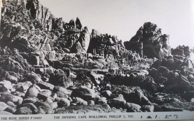
Photograph, The Inferno, Cape Woolamai
Part of a collection of 'Rose & Valentine' series of Post Cards. Copied by John Jansson 1984View on Cape Woolamai showing an outcrop of rocks known as "The Inferno"The Inferno, Cape Wollomai, Phillip Island Victoria. The Rose Series P.10453local history, photography, photographs, postcards, cape woolamai, phillip island, black & white postcard copy, the inferno, rock formation -
 Phillip Island and District Historical Society Inc.
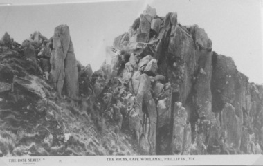
Photograph, The Rocks at Cape Woolamai
Part of a collection of 'Rose & Valentine' series of Post Cards. Copied by John Jansson 1984View on Cape Woolamai of rock formation on western side of Cape."The Rocks" Cape Woolamai, Phillip Island Victorialocal history, photography, photographs, postcards, cape woolamai, phillip island, black & white postcard copy, rock formation -
 Phillip Island and District Historical Society Inc.
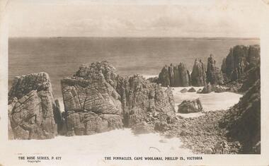
Photograph, Rose Series, The Pinnacles, Cape Woolamai, c.1923
Pinnacles, Cape Woolamai Phillip Island. Beautiful coastal area. Part of the Jessie Smith Collection.View of The Pinnacles - coastal rocks projecting into sea at Cape WoolamaiThe Rose Series P 677. The Pinnacles, Cape Woolamai, Phillip Is., Victoria.local history, photographs, cape woolamai, phillip island, black & white photograph, coastal geography, jessie smith collection, stan mcfee -
Phillip Island and District Historical Society Inc.
Photograph, 1870's
This postcard is contained in an album presented to the then Governor of Victoria, The Earl of Stradbroke, by the fathers of soldiers & returned soldiers of Phillip Island, on 16/02/1923. The history of the album is noted on Reg. No 85-00Postcard showing the rock outcrops known as The Nobbies with Seal Rocks in the background.The Rose Series P747. Nobbies, Phillip Island.local history, photography, photographs, slides, film, the nobbies, seal rocks, sepia photograph -
Phillip Island and District Historical Society Inc.
Photograph, 1870's
This postcard is contained in an album presented to the then Governor of Victoria, The Earl of Stradbroke, by the fathers of soldiers & returned soldiers of Phillip Island, on 16/02/1923. The history of the album is noted on Reg. No 85-00Postcard showing a seal at rest on Seal Rocks.The Rose Series P747. Seal Rocks, Phillip Island.local history, photography, photographs, slides, film, seal rocks, sepia photograph -
Phillip Island and District Historical Society Inc.
Photograph, 1920
This postcard is contained in an album presented to the then Governor of Victoria, The Earl of Stradbroke, by the fathers of soldiers & returned soldiers of Phillip Island, on 16/02/1923. The history of the album is noted on Reg. No 85-00Postcard showing a seals at resting on the rocks with the heads of others appearing in the sea beyond.The Rose Series P652. Seals, Phillip Island.local history, photography, photographs, slides, film, marine wildlife, seals, sepia photograph, phillip island -
 Phillip Island and District Historical Society Inc.
Sepia Photograph, Rose Series, 1920
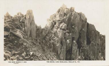
Postcard photo showing rocks on the south side of Cape Woolamai, Phillip Island, Victoria. This formation was named Castle Rock. The Album was presented to the Earl of Stradbroke by Fathers of Soldiers of Phillip Island.Photograph of The Rocks at Cape Woolamai, Phillip Island, VictoriaRose Series P 3426 The Rocks, Cape Woolamai, Phillip Is., Vicphillip island, cape woolamai, earl of stradbroke, castle rock rock formation -
 Phillip Island and District Historical Society Inc.
Sepia Photograph, 1920
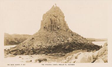
This album was presented to the Earl of Stradbroke by Fathers of Soldiers on Phillip Island. The photo is of the Pyramid Rocks and surrounding rocks, Phillip IslandSepia photograph of Pyramid Rocks, Phillip IslandThe Rose Series P.663 The Pyramid, Cowes, Phillip Is., Victoriaphillip island, pyramid rock -
 Phillip Island and District Historical Society Inc.
Sepia Photograph, 1920
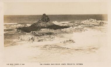
This album was presented to the Earl of Stradbroke by Fathers of the Soldiers on Phillip Island. Photo of beach at Pyramid Rocks with surrounding rocks.Sepia photograph of Pyramid Rocks, Phillip Island. Rocks surrounding the Pyramid with the foaming water.The Rose Series P. 664. the Pyramid, Back Beach, Cowes, Phillip Is., Victoriaphillip island, pyramid rock, earl of stradbroke -
 Phillip Island and District Historical Society Inc.
Sepia Photograph, 1920's
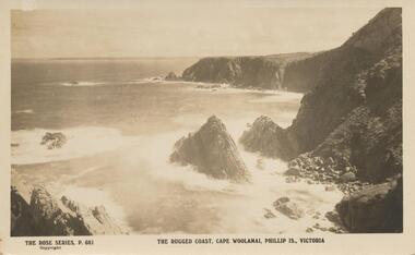
This album was presented to the Earl of Stradbroke by the Fathers of Soldiers and Returned Soldiers 16/2/1923. Photo shows rugged rocks with wavers breaking around the shoreline.Photograph of the rugged coastline at Cape WoolamaiThe Rose Series P. 681. The rugged coast, Cape Woolamai, Phillip is., Victoriaphillip island, cape woolamai, rugged coastline, earl of stradbroke -
Phillip Island and District Historical Society Inc.
Book, GOOCH, Ruth Victoria, Seal Rocks and Victoria's primitive beginnings, 2008
... -island-and-the-bass-coast Book Seal Rocks and Victoria's ...Stamped 'Phillip Island & District Historical Society'.aboriginal australians, victoria, history, aboriginal tasmanians, sealing, western port, seal rocks -
Phillip Island and District Historical Society Inc.
Photograph
Part of collection of Photographs donated to the Museum by the family of the late Mr. Jack Jenner, (1977)Sepia Postcard - Rose Series - No. P669 - View of breakers on rocks."Breakers near The Nobbies, Phillip Island Victoria. the Rose Series No. P. 669local history, photography, photographs, slides, film, view - breakers near nobbies, phillip island, sepia photograph, jack jenner, ocean coastline -
 Federation University Historical Collection
Booklet - Book, Hector Yates, The Basalts and Granitic Rocks of the Ballarat District, 1953
Hector Yates lectured in Geology at the Ballarat School of Mines.Brown soft covered booklet .On front cover "With the author's compliments" "E.J. Tippett"ballarat school of mines, hector yates, ballarat, geology, granite, royal society of victoria, basalt, gong gong - lal lal cupola, burrumbee, mount warrenheip, yendon, green hill, buninyong, garibaldi, hardie's hill, mt mercer, mt lawaluk -
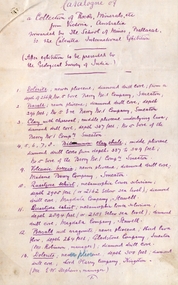 Federation University Historical Collection
Document, SMB: Catalogue of a Collection of Rocks, Minerals, etc, 1883
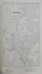
... This list of rocks, minerals, etc. from Victoria... August 1883 This list of rocks, minerals, etc. from Victoria ...This list of rocks, minerals, etc. from Victoria was complied and forwarded by the School of Mines, Ballarat, to the Calcutta International Exhibition. At the end of the exhibition the items were to be presented to the Geological Survey of India. One Hundred items are listed. Pages 4 and 5 also show diagrams relating to the land formations and sections. Places in Victoria are named indicating where items were found. List compiled by Professor Ferdinand Moritz Krause. He joined Ballarat School of Mines in 1880 and lectured in Mineralogy and Geology. He was also the Curator of the Ballarat School of Mines Museum.6 pages, handwrittenSignature of F M Krause Dated 30th August 1883ballarat school of mines, rocks, minerals, calcutta international exhibition, geology survey of india, victoria, professor ferdinand moritz krause, mineralogy, geology, curator, ballarat school of mines museum